Mount Bisoke, a stratovolcano situated within the Virunga Massif, stands at an elevation of 3,711 meters along Rwanda’s northwestern border with the Democratic Republic of the Congo.
It sits entirely within Volcanoes National Park, part of a transboundary conservation zone that includes five other major volcanoes across the Albertine Rift.
The mountain’s summit features a nearly circular crater lake, formed through repeated explosive eruptions and subsequent accumulation of rainwater. Hikers ascend its eastern slope on the Rwandan side, navigating montane forest zones that mark key ecological transitions within the park.
Although Bisoke does not feature gorilla tracking routes, it lies squarely within the same protected zone that shelters over one-third of the world’s remaining mountain gorillas.
For this reason, the area receives the same conservation attention and ranger supervision.
You may already be familiar with Rwanda’s reputation for primate conservation; this hike reveals another side of that effort. It is a regulated and intentional experience, combining moderate physical challenge with interpretive exposure to high-altitude vegetation zones.
The route is accessible on foot in a single day. That said, it still demands proper preparation and a measured pace.
Let’s take a closer look at where the hike begins.
Where is Mount Bisoke Located?
Mount Bisoke is situated within the Virunga Mountains, which span three national borders: Rwanda, the Democratic Republic of the Congo, and Uganda.
The volcano lies entirely within Rwanda’s territory, specifically inside Volcanoes National Park in the country’s northwestern province.
The park covers approximately 160 square kilometres and is part of the larger Albertine Rift conservation block.
The nearest urban centre is Musanze, formerly known as Ruhengeri. This district serves as the base for most visitors planning a hike to Bisoke. From Kigali, Rwanda’s capital, the drive to Musanze takes approximately two and a half hours by private vehicle or with a registered tour operator. The route follows paved roads and is considered one of the most accessible high-altitude hiking destinations in the region.
Mount Bisoke stands between Mount Karisimbi to the west and Mount Mikeno to the north, both of which are part of the same volcanic arc. Although Mikeno lies in DRC territory, Karisimbi shares a border with Rwanda.
From specific vantage points, you may see as many as five volcanic cones within the same skyline, Bisoke among them.
Access to the hiking trail begins at the park’s headquarters in Kinigi. This is where briefings are held, permits are verified, and hikers are assigned guides and armed rangers.
The actual trailhead sits roughly 40 minutes from Kinigi by 4×4 vehicle, and transfer logistics are typically coordinated in advance.
If you’re wondering whether proximity to DRC affects security, the answer is no. Rwanda has a long-established park infrastructure on its side of the massif, with a professional ranger force and strict visitor protocols. Cross-border hiking is not permitted.
What Makes the Mount Bisoke Hike Special?
Volcanic Summit with a Crater Lake
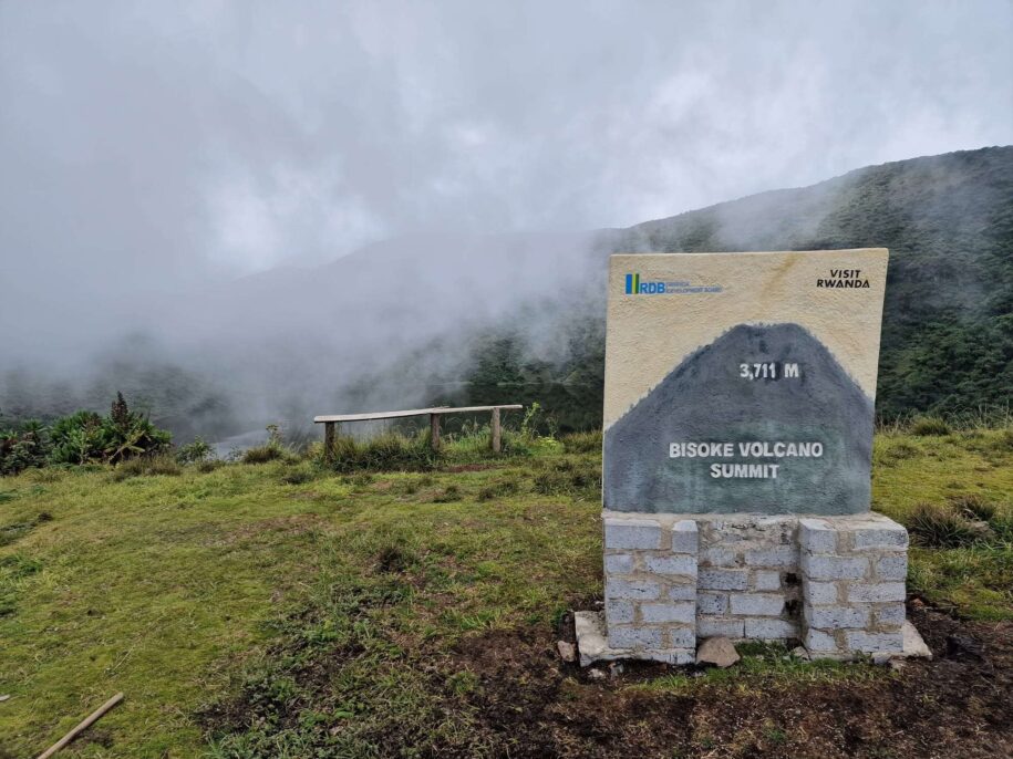
Mount Bisoke culminates in a nearly perfect circular crater filled with water, measuring approximately 400 meters in diameter.
This summit lake, situated at 3,711 metres above sea level, remains one of the few accessible volcanic crater lakes in the Albertine Rift. Although cloud cover is standard, clear mornings reveal the lake’s steep internal walls and a greenish-grey hue.
No boating or swimming is permitted. The summit remains stable, although hikers are advised not to descend into the crater due to the risk of the slopes.
Geological and Seismic Relevance
The volcano belongs to the Virunga chain, part of the larger East African Rift System.
Its formation dates back thousands of years, with the most recent recorded eruption in 1957. The massif remains volcanically active, although Bisoke’s current state is dormant.
Seismic monitors operate in the park, coordinated through regional geological observatories. If you have a professional interest in volcanology, the hike offers a living case study of stratovolcanic processes, erosion gradients, and rift tectonics.
Ecological Zonation Along the Trail
The trail offers a vertical sampling of mountain ecology.
You begin in a bamboo forest zone (Arundinaria alpina), pass through hagenia woodland (Hagenia abyssinica), and ascend into afro-alpine meadows dominated by lobelias and senecios.
These changes occur between 2,400 and 3,600 metres. This altitudinal gradient supports high plant endemism and seasonal bird activity.
Wildlife sightings are not guaranteed, but the park is home to a variety of animals, including golden monkeys, duikers, and hyraxes. Armed rangers remain vigilant for signs of primate movement.
High-Altitude Challenge Without Technical Climbing
The Mount Bisoke hike gains over 1,200 metres in elevation in a single ascent.
Although the trail presents no vertical climbs or rope sections, its gradient and soil conditions demand physical readiness.
Slippery mud, exposed roots, and narrow bends require steady footing. Most visitors complete the round trip in five to seven hours.
There is no infrastructure at the summit—no shelters, no fencing, no benches. You walk up, observe, and descend. For many, that directness is part of the value.
Conservation-Centered Management and Access
Rwanda Development Board (RDB) oversees the trail, assigns licensed guides, and ensures hiking groups follow conservation protocols.
All proceeds from permits contribute to Volcanoes National Park’s broader protection mandate, which includes gorilla conservation, ranger salaries, and mitigating human-wildlife conflicts in buffer communities.
The hike itself does not intersect with known gorilla families, but all visitors receive a safety briefing on how to behave if that changes.
READ ALSO: Understanding the $1500 cost of Gorilla Trekking in Rwanda
Hiking Route and Difficulty
The hike to Mount Bisoke begins at the Volcanoes National Park headquarters in Kinigi, located at an altitude of approximately 2,400 metres.
All visitors must report here by 7:00 AM for a mandatory briefing. The briefing covers environmental protocol, health checks, ranger allocation, and group organisation.
The Rwanda Development Board assigns guides, and each group typically includes an armed ranger and occasionally a porter.
After registration, hikers transfer by vehicle to the trailhead near the Bisate sector. The transfer typically lasts 40 minutes.
The actual walk begins at an elevation of approximately 2,700 metres. From here, the trail climbs steadily through a bamboo forest. The ground remains damp and occasionally waterlogged, particularly during or after rainfall. Wooden walking sticks are issued, and it would be wise to accept one.
Within the first 45 minutes, the trail becomes increasingly steep. You pass into a transitional zone where bamboo gives way to hagenia woodland.
The roots here are exposed, and the mud deepens on inclines. Porters often recommend stepping on side ridges rather than the centre trench, which collects runoff and degrades quickly. It’s helpful to watch how they move.
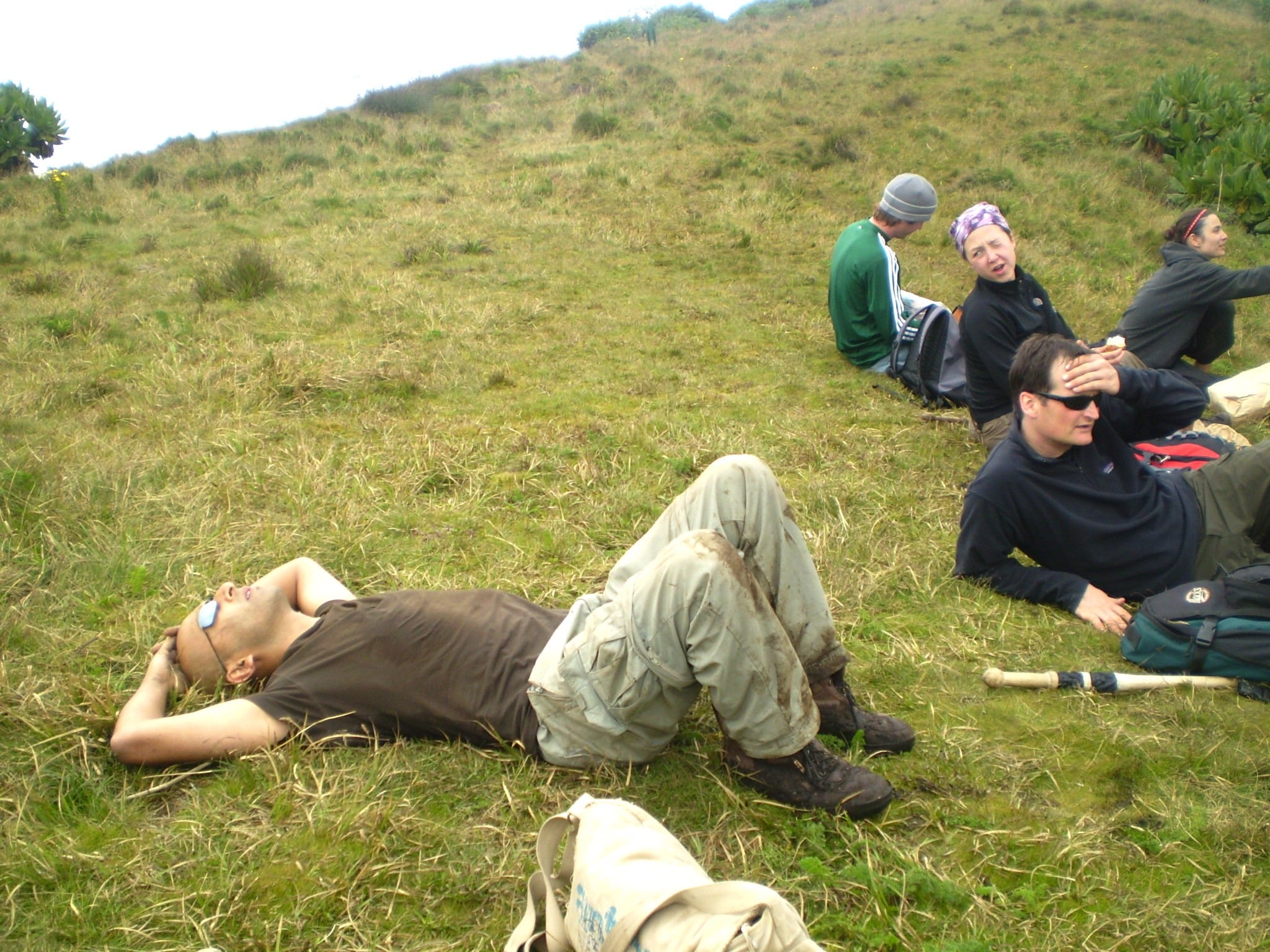
At roughly 3,200 metres, vegetation becomes sparse. This is the afro-alpine belt. Lobelia deckenii and Senecio species dominate, but the weather often turns cold and windy. Visibility varies from 50 to 500 metres depending on cloud density.
At this altitude, oxygen levels drop slightly, and most people begin to notice a reduced pace.
The final stretch to the summit is the most physically demanding. You gain the last 400 metres in less than an hour on a narrow ridge.
The soil underfoot is soft and loose, and hikers must balance carefully, especially during wet periods. Some groups stop several times here, not just for breath but also for coordination.
You will need stamina, but not special climbing skills. That said, if you have a history of altitude sensitivity, hydrate early and walk at your own pace. It’s not a race, even if others seem to treat it like one.
Entry Requirements and Permits
The Rwanda Development Board (RDB) regulates all hiking activities within Volcanoes National Park. It is the sole issuer of official permits for Mount Bisoke hikes.
No private entity is licensed to operate independently within the park. All hikes must be registered through RDB channels.
Permit Cost and Inclusions
As of September 2025, the cost of a Mount Bisoke hiking permit is USD 75 per person. The permit includes:
- Access to the park for one day
- Professional guide services
- Armed ranger escort
- Basic hiking stick (issued at briefing)
- First aid supervision on the trail
The permit does not cover transport to the trailhead, porter fees, meals, or accommodation.
Booking Procedure
Permits must be secured in advance through the RDB or a licensed tour operator. Direct bookings can be made via RDB’s online portal or at the Volcanoes National Park office in Kigali. For international visitors, working through a registered Rwandan tour company is often more efficient. Most operators include this fee in packaged itineraries.
To confirm a slot, you must provide:
- Full passport details
- Preferred hiking date
- Proof of payment
Permit availability is limited to daily quotas, and peak travel months (June to September, December) fill up quickly.
Day-of Entry Requirements
You must report to the Kinigi park headquarters before 7:00 AM on the day of your hike. Late arrivals are not accommodated.
You must present your permit confirmation, a valid passport or national ID, and undergo a quick health check. The park issues identification tags for all registered hikers. Entry is denied to individuals without valid documentation.
Age and Fitness Guidelines
Participants must be at least 15 years of age. There is no upper age limit; however, guides reserve the right to stop a participant from proceeding if their fitness level poses a safety risk. No formal medical certificate is required, but personal readiness is assumed.
If you’re considering hiking Bisoke as part of a larger itinerary, it’s helpful to book early. That way, you won’t have to negotiate availability at the last minute.
What to Expect on the Trail of Mount Bisoke
Initial Ascent: Bamboo Forest (2,700 to 2,900 metres)
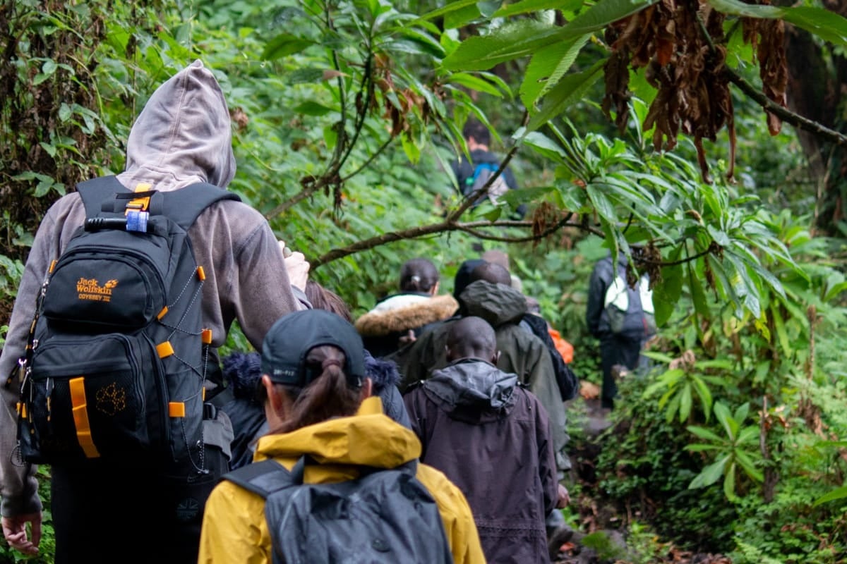
The trail begins in thick bamboo vegetation. The undergrowth is compressed and often muddy. Hikers walk in a single file, led by the guide. Rain collects here more than in the upper zones, so water-resistant boots are essential. The air remains humid, and insects gather early in the season. Rangers walk with rifles but rarely intervene unless wildlife crosses the path.
Mid Elevation: Hagenia Woodland (2,900 to 3,200 metres)
Bamboo gives way to hagenia trees. These stretch tall, with reddish bark and wide canopies. Their leaf litter sometimes conceals slippery roots. Here, you might hear tree hyraxes, though you’ll probably never see them. Golden monkeys occasionally move through this zone, especially early in the day. The trail narrows further and begins to tilt. Breathing becomes heavier, but conversation continues to flow among groups.
Afro-Alpine Belt: Lobelia and Senecio Zone (3,200 to 3,600 metres)
The air thins. Tall lobelias appear alongside giant senecios with fuzzy trunks. The tree line drops, and visibility opens—when clouds allow. This zone feels exposed, and the wind begins to pick up. The trail shows signs of erosion here. Stones become more frequent underfoot. Most hikers take one or two stops here. Guides usually set the pace, but if you’re slower, they adjust quietly to accommodate you. No one pressures you to speed up.
Summit Approach: Steep Open Ridge (3,600 to 3,711 metres)
This section defines the climb. The final ridge offers no shelter, and the wind can be cold, regardless of the season. Your legs will feel the incline more here than earlier. The summit has a sharp lip—then the crater appears. The lake sits still. Some days it reflects the sky. Other times, it holds mist like a bowl. There are no signs, no benches, and no built edge. You stand, take in the view, and usually descend after 10 to 15 minutes.
Return Walk
The way down uses the same path. Slipping becomes more likely as fatigue sets in. Porters often walk ahead to help guide foot placement. Most injuries occur on descent, especially on wet days. You’ll begin to hear the sound of vehicles before you see them. That’s how you know the hike is ending.
And yes, you’ll feel it the next day in your calves.
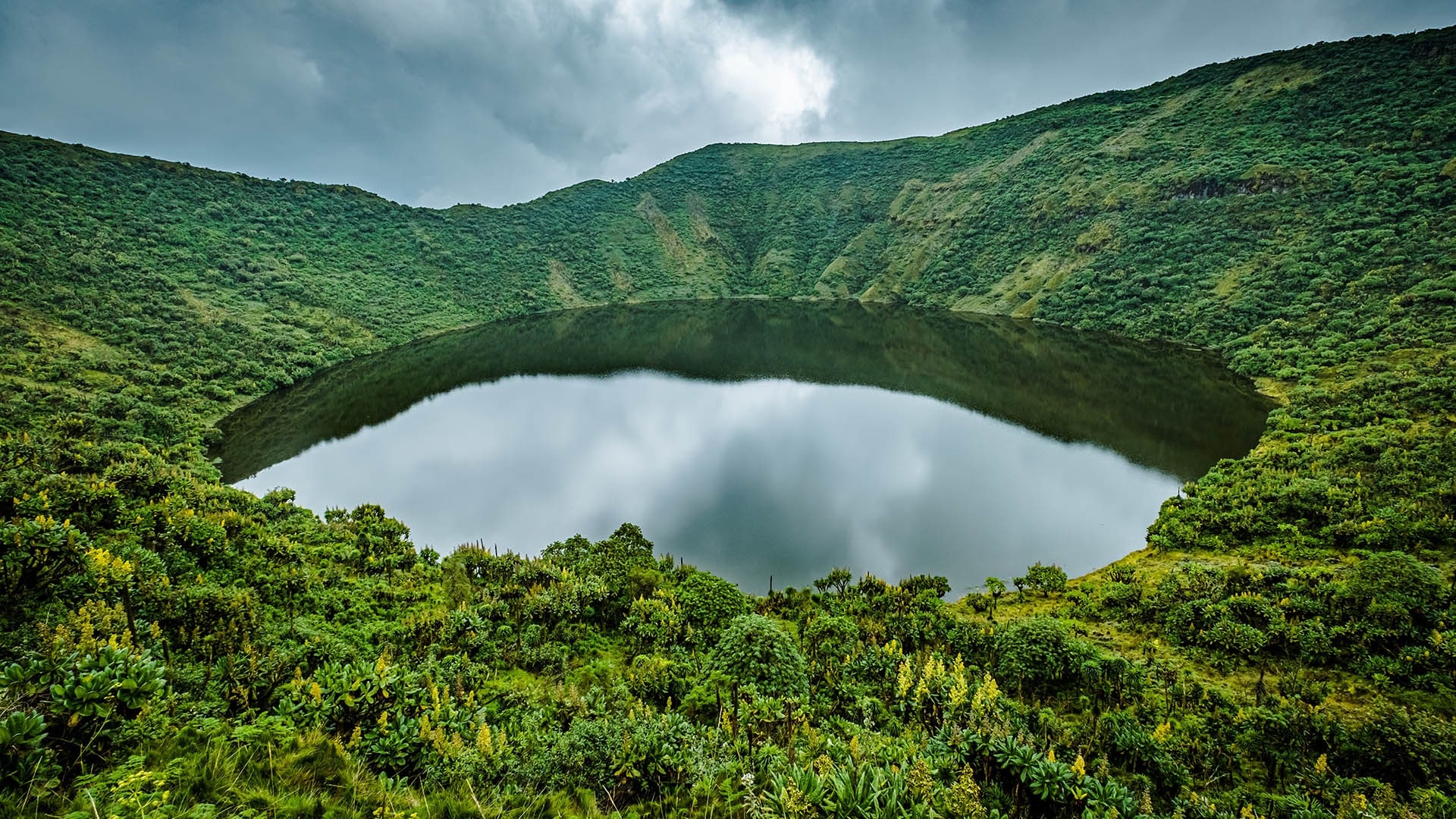
The Crater Lake at the Summit
At 3,711 metres above sea level, Mount Bisoke’s summit holds a circular volcanic crater filled by a permanent lake. The water spans roughly 400 metres in diameter, with steep internal walls dropping unevenly toward the centre. Depth remains unmeasured by official sources, but it appears shallow near the edges during rare snowmelt periods. The lake surface rarely shows movement. No streams are flowing in or out.
The summit ridge encircles the crater, forming a complete arc that is accessible on foot. Hikers reach it from the southeastern side and stop on the rim above the water. Vegetation disappears entirely here, leaving exposed soil, loose rock, and traces of earlier foot traffic. Rangers discourage movement around the full rim for erosion control and safety.
During clear conditions, the lake appears still and has a grey-green color. In the early morning, it sometimes reflects the surrounding light and outlines. Cloud formations enter and exit rapidly at this elevation. Most groups reach the summit when visibility ranges from 30 to 150 metres. Complete clarity is less common, especially during rainy months.
There is no infrastructure at the summit. No shelters, viewing decks, or trail markers exist. Visitors stand on bare earth. The experience is direct. It’s also brief. Groups spend between 10 and 20 minutes at the top, depending on time, weather, and ranger instructions.
Ecologically, the lake supports no known fish or macrofauna. Mosses and algae grow seasonally on the rim, but biodiversity is limited due to the altitude and cold temperatures. Snow does not accumulate, though light frost has been reported on surrounding rocks during June and July.
What to Pack for the Mount Bisoke Hike
- Waterproof hiking boots with ankle support
- Thick hiking socks (carry an extra pair)
- Rain jacket or poncho (weather changes quickly)
- Lightweight warm layer (fleece or softshell)
- Base layer for moisture wicking
- Hat or cap for sun protection
- Gloves for cold summit conditions
- Refillable water bottle or hydration pack (minimum 2 litres)
- High-energy snacks (nuts, protein bars, dried fruit)
- Walking stick (provided, but bring your own if preferred)
- Daypack or small backpack with chest strap
- Headlamp or flashlight (in case of delays)
- Plastic bag or dry sack for electronics and documents
- Passport or ID for park check-in
- Camera or binoculars (optional, carry with waterproof protection)
- Altitude medication (optional, consult your doctor)
- Hand sanitiser and personal tissues
- Basic first aid items (plasters, ibuprofen, insect repellent)
Best Time to Hike Mount Bisoke
June to Mid-September (Dry Season)
This period offers the most stable trail conditions. Rainfall reduces significantly, and skies remain clearer during the morning hours. Visibility at the summit improves, though clouds still move fast—daytime temperatures in Musanze range between 16 and 22 degrees Celsius. The trail dries but remains soft underfoot. RDB reports the highest number of hikers during this window.
December to February (Short Dry Season)
Clear mornings return, but sporadic afternoon rains may resume. Vegetation grows thicker along the bamboo zone. Mornings feel cooler, especially above 3,000 metres. Visibility fluctuates more than in June, yet the trail remains accessible. It is a great time for visitors to combine hiking with other activities in Volcanoes National Park.
March to May (Long Rains)
Rains increase and trail conditions become more difficult. Mud depth worsens between 2,800 and 3,200 metres. The final summit stretch often becomes unstable. Mist persists most of the day, limiting views. Guides monitor the group pace more closely. Some tour operators reduce departures during this time, but the park remains open.
October to November (Short Rains)
Rainfall returns in cycles, and storms pass through quickly. Hikes continue, but rangers assess safety on a daily basis. Vegetation regrows rapidly, and bamboo segments become slippery. Water accumulation is typical in trail gullies. Fewer hikers visit during this season, but porters may be more readily available.
Time of Day
All hikes begin in the morning. Groups must check in by 7:00 AM at Kinigi headquarters. Departures occur before 8:30 AM, depending on group size. Afternoons typically bring heavier cloud buildup, and late returns risk slippery descent. You’ll want to begin early. Most people do.
Conclusion
Mount Bisoke offers a direct and measurable opportunity to experience the structure of a live stratovolcano through a guided, single-day ascent. Its crater lake summit, standing at an elevation of over 3,700 metres, offers a rare geological and visual endpoint that remains physically accessible to prepared hikers.
The trail itself transitions through ecological zones that demonstrate vertical biodiversity typical of the Albertine Rift. That, paired with its position inside Volcanoes National Park, places the hike within a well-regulated, conservation-aligned framework.